On the 6th of November, one month after the start of the Israel-Hamas conflict, we published an article where we investigated the perceived increased in GNSS jamming in the region. Now, 6 months into the conflict and 2 ½ years into the full-scale invasion of Ukraine, we revisit the state of the GNSS spectrum around the world. First, we will discuss why GNSS jammers are used. Secondly, we discuss what the effects are of these jammers on the global scale. Finally, we take a look at the GNSS interference status in Central Europe and the Middle-East.
We use GPS and GNSS devices to accurately determine positions and reference times around the world. In this sense, GNSS is unparalleled as it provides a global navigation service, even when local infrastructure is destroyed. Every modern military makes use of GNSS positioning for military operations, whether it is to position units or ships, or to guide drones or other weapons. While only 30 years ago GNSS technology had limited use outside its military applications, it is nowadays an incredibly widely used technology in everything from watches to wind turbines.
GNSS receivers are categorized as a potential dual-use technology: it has a civilian use, but can also be used in a military setting. For example, certain receivers that serve the latter category, would require an export license. Nevertheless, in last couple of years the proliferation of commercial drones in military use has created a situation where practically any civilian-grade GNSS receiver could be used for military purposes.
There are three major reasons why a state-actor would use GNSS jammers:
- Disturb civilian infrastructure, such as jamming of GNSS signals in critical infrastructure, maritime environment or air traffic.
- Disturb military processes, such as the jamming of operations.
- Jamming defensively to deny adversaries to use GNSS over your own territory. This is currently observed in Israel and Russia, where GNSS is jammed [VV1] over large parts of the country.
As GNSS signals are electromagnetic waves, the signals coming from jammers follow a similar propagation as radio waves. This means that the jammed signal strength remains quite strong as long as you maintain a line of sight with the jammer. If you are at ground level, a signal coming from a jammer does not propagate much further than a few kilometers, until the signal becomes dissipated by buildings, foliage and the curvature of the Earth. For drones and airplanes, this is a different story, as the jammed signal can propagate much further, even over the horizon. As such, airborne GNSS receivers are the canary in the coal mine, and the most likely victims of large scale jammers. This has impact not only for the areas affected by GNSS interference, but also the airplanes traveling through these areas, as mentioned by KLM.
The website gpsjam.org collects data from airborne receivers through the open ADS-B data, and gives an indication of the amount of interference in a certain area. The green areas show low interference (0-2%), while the yellow and red areas shown a medium (2-10%) and high interference (>10%).
Before the Russian invasion of Ukraine, it can be seen that jamming was already presented in the Middle-East, and to a smaller extend in Russia. The GPS jamming was mainly present around major airports and governmental institutions, to prevent the flight of drones over these areas.
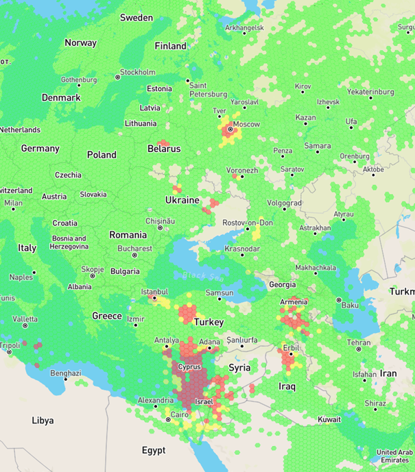
Figure 1 Interference on 2022-02-22. Source: gpsjam.org
Nowadays, the amount of interference has dramatically increased, with a major increase in jamming over Finland, the Baltic States, Poland and the Black Sea. No data is visible from Ukraine, as not enough aircraft operate over the country with ADS-B transceivers enabled.
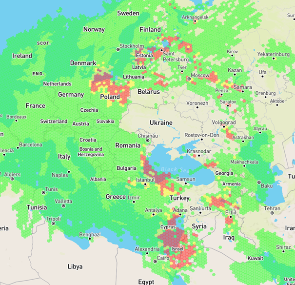
Figure 2 Interference on 2024-03-25. Source: gpsjam.org
Within Ukraine itself, GPS jammers are commonplace. Earth-Observation missions use GNSS reflectrometry to carry out Earth Science research. However, due to the extensive use of jammers, spoofers and GPS flex power, this is no longer possible over a growing region of Eastern Europe.
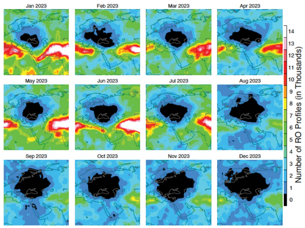
Figure 3 Decrease of Radio Occultation Profiles over Eastern Europe. Source: https://www.gpsworld.com/research-report-a-black-hole-in-earth-science/
In conclusion, the amount of GNSS interference is on the rise and will likely continue to remain high due to the importance of GNSS systems in modern civilian and military activities. While GPS is certainly still a very valuable tool for many applications, the current reality is that the use of GNSS comes with a serious risk of service disruptions. Similarly to aircraft, who have backup systems such as guidance beacons and inertial navigation systems, it would be wise for the other applications to have built-in contingencies for GNSS interference events.